Chhattisgarh tiger reserve finds 2,500 trees girdled. Satellite images show scale
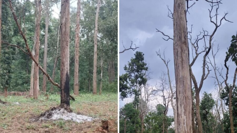
On closer inspection, which included looking into satellite images, it has come to light that villagers have been returning to the area over the last two decades. In the last one decade, they have allegedly cleared 30,000 trees in the protected forest for cultivation.
Story continues below.
Subscribe to see fewer ads.
With Karka forming part of an important forested landscape and wildlife movement corridor, including an elephant corridor, degradation of habitat can increase the potential for human-wildlife conflict, officials said.
Karka was historically a forest village situated in the catchment of the Sondhur dam, within the erstwhile Sitanadi Sanctuary
Following construction of the dam, the village was relocated in the 1980s
While forest authorities said people have been returning despite getting compensation, many villagers claimed they never got any relief and hence, never moved out.
Story continues below this ad
“As per available departmental records, 55 people of the village received compensation from the Water Resources Department. Despite the lawful compensation, forest land in the upstream area has subsequently been subjected to encroachment and clearing,” said deputy director of USTR, Varun Jain.
A preliminary investigation by forest officials, including the use of ISRO images, showed crop fields near the submerged area in 2006. By 2016, 22 hectares upstream was encroached.
Back then, a Preliminary Offence Report (POR) was registered but 20 persons booked in the case were acquitted. The encroachment continued, and increased. And as of 2026, more than 30 hectares were found encroached.
Reduction in forest cover
During the latest field assessment on September 22, the Forest Department has found evidence of extensive forest degradation.
Story continues below this ad
“We have calculated that over 2,500 trees have been girdled (over the last few years) due to which they slowly die. The calculation is ocular, by comparing the tree density in adjacent forest areas using sample plots (adjacent area shows more than 1,500 trees/hectare while the encroached area shows only 50-100 trees per hectare),” said Jain. “This is why 2016 imagery shows a dense forest, but 2017 shows a stark reduction in forest cover as the trees had dried and died in one year (due to girdling),” he added.
The forest team faced strong resistance from 40 to 50 villagers during their investigation. A fresh POR has been registered against two villagers in the matter.
On the other hand, around 32 families from Karka said they continued to stay inside the reserve because they never got compensation even as others who received it moved out. Bhagwan Singh, 32, from the village told , “The 32 to 33 families never got compensation. At first, the forest department offered us 5 acres and Rs 15 lakh to move out of the reserve but when we refused (as we did not want to move out), they started alleging encroachment.”
They have found support in the Gram Sabha Federation, an umbrella body of all Gram Sabhas in tiger reserves, with its president Ishwari Lal Netam saying, “It is true that the trees have been girdled. Though we cannot estimate how many have been girdled, the figure is not as high as the forest department claims.”
Story continues below this ad
A forest official, however, said, “They got Community Forest Resource Rights (CFRR) in 2020 in 2,208 hectares and they were supposed to protect the forest but instead, they are cutting thousands of trees. We shall take appropriate action.”
The community forest resource area is the common forest land that has been traditionally protected and conserved for sustainable use by a particular community.
CFRR provides for recognition of the right to “protect, regenerate or conserve or manage” the community forest resource.
At present, GPS-based mapping of the encroached area is underway along with DGPS-enabled drone mapping where minute details are clearly available. This drone generated imagery will be compared with ISRO imageries to get an accurate assessment of the extent of forest cover loss.
Story continues below this ad
“A DGPS drone survey was conducted two days ago in the presence of police personnel. Based on the exact area identified through the survey, the names of the accused will be added to the registered POR, following which 80A notices will be issued, directing them to vacate the encroached land,” Jain told .
The forest department has also initiated a departmental enquiry against a beat guard and range assistant. They allegedly resisted registering the POR for 20-25 days after the matter came to light, giving rise to suspicion that they were aware of the matter but had been turning a blind eye to it all this while.
“In last four years, USTR administration has freed 1,050 hectares of encroached forest land and the field staff, operating with a 65% vacancy in sanctioned strength, have faced five attacks by villagers. About 200 to 300 hectares inside USTR is still encroached upon, including in Karka,” added Jain.

Uttarakhand’s SIR final roll is out — but the voter enrolment exercise isn’t over yet
By Sohail Khan · 3 Oct
Report FIRs, arrests against AGMUT officers within 48 hours: Centre
By Sohail Khan · 3 Oct

Leave a Reply