Nepal tragedy shows climate ignores borders. China and India must understand this
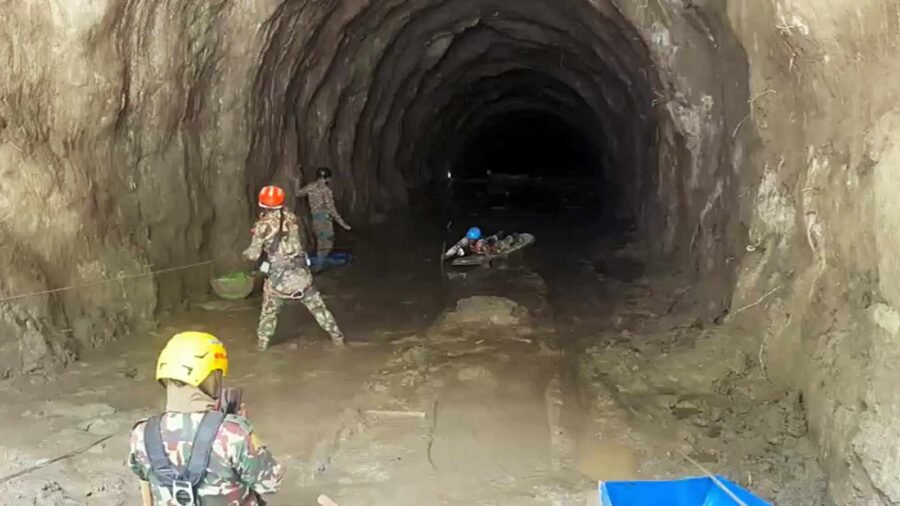
The recent catastrophe that struck Nepal offers a devastating reminder of the fragile, interconnected ecological reality of Himalayan Asia. A sudden collapse of ice and rock high in the mountains above the border region transformed within minutes into a violent surge of water, mud, and debris, sweeping through settlements, crushing critical infrastructure, and claiming over a thousand lives. The shockwaves of this tragedy were felt immediately in Kathmandu, where I happened to be visiting, along with various diplomats, politicians, and global observers gathered for pre-planned commitments.
During a high-profile conclave hosted in the capital by a leading Indian television news channel, the gravity of the situation completely reshaped the agenda. Addressing the audience, Rabi Lamichhane, the leader of the ruling Rashtriya Swatantra Party, made a poignant observation that cut through standard diplomatic platitudes. He noted, almost in passing, that whatever the prevailing geopolitical frictions, strategic rivalries, or sovereign boundary disputes among India, China, and Nepal, all three nations unavoidably share a single, unified mountain system. His remarks underscored a shared sentiment reverberating across Kathmandu: This tragedy was not merely an isolated localised accident, but a stark manifestation of accelerated global warming. It is a bitter irony that Nepal, whose greenhouse gas emissions are virtually negligible, bears the most brutal, immediate consequences of global climate change, while its vast, highly industrialised neighbours, especially to the north, account for a substantial portion of the atmospheric warming driving Himalayan glacial collapse.
Advertisement
Glaciers do not recognise international boundary lines, nor do glacial lakes, river basins, or atmospheric currents. When a glacial lake bursts, a landslip dams a transboundary river, or an ice-rock avalanche releases millions of cubic metres of meltwater, creating a “barrier lake” that could burst at any time, the ensuing deluge flows downstream across sovereign frontiers. Yet, despite this undeniable physical unity, regional governance of the Himalayan biome remains deeply fragmented. The current crisis demonstrates the urgent necessity of establishing an institutionalised tripartite mechanism among India, Nepal, and China dedicated exclusively to ecological protection, real-time hydrological information-sharing, and joint climate adaptation efforts.
Designing such an institutional framework requires a clear-eyed assessment of the region’s historical track record regarding ecological transparency. Cooperation between upper-riparian and lower-riparian states in the Himalaya has historically been uneven, reactive, and constrained by national security secrecy. Both India and Nepal have repeatedly expressed deep dissatisfaction with the quality, frequency, and timeliness of hydrological and geological data shared by China.
China controls the Tibetan Plateau, the crucial source of headwaters for Asia’s major river systems, including the Yarlung Tsangpo (Brahmaputra), the Indus, and the upper tributaries of the Ganges, such as the Bhote Koshi and Karnali. Over the years, Beijing’s approach to sharing hydrological data during the monsoon season has been governed largely by transactional, bilateral MoUs rather than automatic, open-data commitments. Lower-riparian nations have often been left in the dark during critical moments.
Advertisement
For instance, during previous incidents involving natural dams formed by massive landslides in Tibet, both Indian authorities in Arunachal Pradesh and Assam, as well as downstream Nepali communities, faced terrifying delays in receiving actionable flow rates or structural assessment data from Chinese monitoring stations. Similarly, when flash floods and artificial lake formations occurred along upper transboundary tributaries like the Pareechu River or the Bhote Koshi, downstream countries were often forced to rely on delayed commercial satellite imagery rather than immediate, official hydrological alerts from Beijing. Even existing bilateral mechanisms between India and Nepal, while more operational, have frequently suffered from administrative friction, inadequate instrumentation in remote high-altitude zones, and a lack of integrated early-warning architecture spanning the higher Himalaya down to the Gangetic plains.
If a tripartite environmental mechanism is to succeed where past arrangements have stumbled, it must transcend political posturing and operate on a purely technical, life-saving imperative. This requires three distinct pillars of engagement.
First, information-sharing must be transformed from a discretionary political courtesy into an automated, real-time protocol. High-altitude hydrometeorological stations, seismic sensors, and automated water-level gauges situated across Tibet, northern Nepal, and the Indian Himalayan region must feed into a shared regional data grid. Downstream communities in Nepal and India cannot afford to wait hours for administrative clearances in foreign capitals when a glacial outburst flood can travel downstream in a matter of minutes. Real-time satellite data, telemetry, and flood hazard modelling must be made accessible to emergency responders across all three nations simultaneously.
Second, joint ecological research and risk mapping must replace isolated national assessments. Thousands of potentially dangerous glacial lakes are scattered across the Hindu Kush-Himalayan range, many of them expanding rapidly as global temperatures rise. Mapping these hazards, assessing the structural stability of hanging glaciers, and predicting destabilising landslips requires joint scientific expeditions, cross-border remote sensing analysis, and shared ecological modelling. Establishing a joint scientific council under a tripartite banner would allow researchers to pool expertise.
Third, feasibility-based joint action must be pursued on the ground. Where high-risk glacial lakes threaten settlements across borders, joint engineering interventions (such as controlled siphoning, artificial drainage channels, or structural reinforcement) must be undertaken collaboratively. Coordinated disaster response drills and cross-border environmental conservation projects can build functional trust among military and civilian disaster response agencies that otherwise view each other through a lens of geopolitical suspicion.
The Himalaya is warming at a rate significantly higher than the global average, threatening the water security, safety, and livelihoods of over a billion people downstream. Nations can negotiate political boundaries, but they cannot negotiate with physics, geology, or changing atmospheric temperatures. As Rabi Lamichhane pointed out, the mountains bind India, China, and Nepal to a shared destiny. Establishing a dedicated, transparent tripartite mechanism for environmental cooperation is an absolute necessity for survival in an age of climate crisis.
The writer is a fourth-term Member of Parliament (Lok Sabha) for Thiruvananthapuram and chairman of the Parliamentary Standing Committee on External Affairs


Don’t buy a lab-grown diamond before checking these 7 things
By Sohail Khan · 29 Sep
Towards a gender just Uniform Civil Code
By Sohail Khan · 29 Sep