Bihar is flooded despite poor rains and Nepal is not the reason: Here’s what is
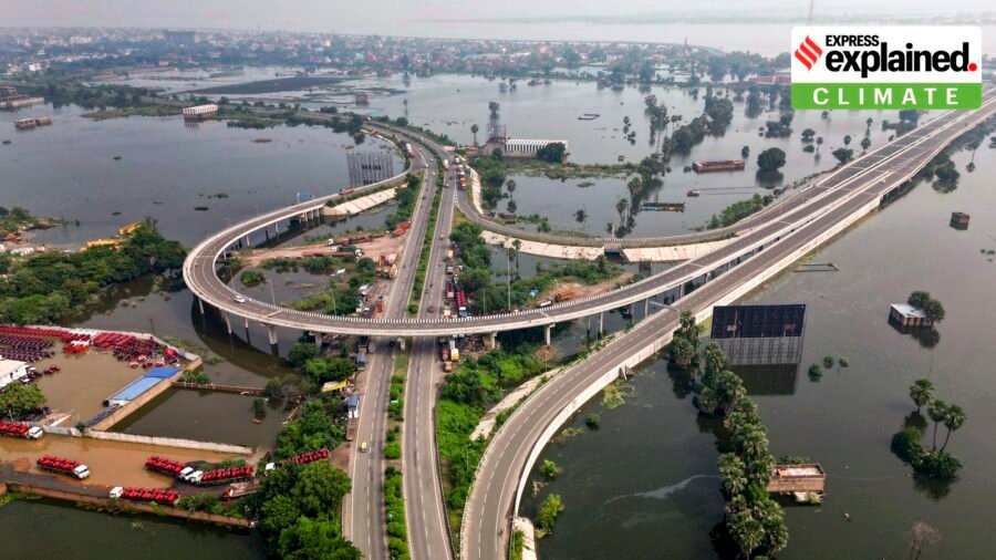
For much of the monsoon, Bihar was facing a problem associated with droughts rather than floods. Between June 1 and September 8, the state received 601.1 mm of rain, 27% below normal. As late as September 1, the deficit was 30%. Then the rivers rose sharply.
The Ganga crossed its previous highest flood level (HFL) at Patna and Bhagalpur. At capital’s Gandhi Ghat, it reached 50.58 metres, six centimetres above the previous HFL of 50.52 metres recorded in 2016. At Sultanganj in Bhagalpur, the river touched 36.80 metres, five centimetres above its previous HFL of 36.75 metres set in 2021.
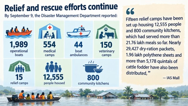
By September 9, the Disaster Management Department reported 84 affected circles, 518 panchayats and 2,157 villages across 14 districts, with about 40.51 lakh people affected.
Story continues below.
Subscribe to see fewer ads.
So how did Bihar flood despite a substantial rainfall deficit? We explain
Nepal disaster, Gandak and Ganga’s unusual flood sequence
Deputy Chief Minister and Water Resources Minister Vijay Kumar Choudhary said on September 7 that this year’s flood pattern was different from previous years.
“Normally, the rivers entering Bihar from Nepal — the Bagmati, Kamla, Kosi and Gandak — rise first, followed by the Ganga. This time, the Ganga became the main source of concern first,” he said.
As Ganga’s catchment extends far beyond Bihar, it receives water generated by rainfall upstream, including from Uttar Pradesh.
Story continues below this ad
Bihar Disaster Management Department Principal Secretary Santosh Kumar Mall told that “rainfall around the Allahabad and Varanasi region, and the resulting downstream discharge, were important factors behind the Ganga’s rise. For other rivers too, discharge from neighbouring states was a major factor.”
Meanwhile, Bihar recorded heavy, localised rainfall during the period when the flood situation worsened, including 214.92 mm in East Champaran and 154.55 mm in Sitamarhi in individual rain events.
While cumulative rainfall remained 27% below normal up to September 8, rainfall during September itself was 31% above normal.
On August 26, a glacial lake outburst in Tibet caused severe flooding in Nepal. The Bihar Water Resources Department (WRD) quickly responded by opening all the 36 gates of the Valmikinagar Barrage on Gandak, which was below its normal levels. The river’s discharge at the barrage reached 1,50,200 cusecs at 11 pm on August 26, less than what officials had expected, and then declined.
Yet flooding continued.
Story continues below this ad
One reason was the unusually high level of the Ganga. Choudhary said Ganga created a “backwater effect” for rivers such as the Gandak and Punpun.
These rivers eventually have to drain into the Ganga but once it swelled, tributaries found it harder to drain. The Punpun was also affected by heavy rainfall in Jharkhand.
The river network explains the spread
“The Ganga enters Bihar at Buxar and runs eastward across the state, affecting a large floodplain that also includes Bhojpur, Patna, Vaishali, Saran, Begusarai, Lakhisarai, Munger, Bhagalpur and Katihar,” IAS Mall said, “North Bihar’s major rivers — the Gandak, Kosi, Bagmati and Burhi Gandak — come down from Himalayan and Nepal catchments into the state’s extremely flat plains.”
The Kosi remained high during the episode. The river was above the danger mark at Baltara in Khagaria and Kursela in Katihar.
Story continues below this ad
The Gandak was above the danger mark at Dumaria Ghat and Hajipur. The Burhi Gandak was above it at Khagaria, the Bagmati at Benibad, the Punpun at Sripalpur and the Ghaghra at Darouli and Gangpur Siswan.
“The Ganga itself remained above the danger mark at several locations, including Patna’s Digha, Gandhi Ghat and Hathidah, as well as gauges downstream in Munger, Bhagalpur and Kahalgaon,” the official said.
Since a river flood is a moving event, peak at one gauge often gets transferred downstream, with flood affecting a much larger area than the places that recorded the heaviest rainfall.
Embankments can hold and flooding can still occur
“Bihar has built more than 3,730 km of river embankments, which helped during floods,” said Mall. These structures have historically protected around 3,600 sq km of land.
Story continues below this ad
While flooding affected low-lying areas reportedly through seepage, local damage, overtopping of older structures and drainage problems, the department said no major modern scientific embankment suffered a large breach during the recent episode.
But embankments do not eliminate one of India’s flattest, most sediment-heavy alluvial landscape’s underlying flood vulnerability.
“The Ganga, Gandak, Kosi, Bagmati and other rivers carry enormous amounts of sediment. When sediment accumulates within channels over years, the riverbed can rise relative to the surrounding land,” said Mall, describing silt as a “permanent issue” for Bihar’s rivers.
Sediment accumulation and downstream hydraulic conditions around Farakka could also potentially influence Ganga levels and backwater conditions.
Story continues below this ad
State leaders contend that over the five decades since its construction, the Farakka Barrage has also played a role, as it trapped massive amounts of silt along the Ganga. This extensive sediment accumulation has made the riverbed dramatically shallower. As a result, even normal seasonal monsoon flows now routinely spill over the banks, triggering severe, annual flooding across the state’s plains.
As the 1996 India-Bangladesh Farakka Treaty approaches its expiration in December 2026, Bihar’s political corridors are echoing with urgent demands to review and scrap the pact.
Bihar’s geography adds another layer. The Ganga, Gandak and Kosi constantly reshape their channels and create diara lands — shifting riverine islands and low-lying tracts that are cultivated and inhabited but remain highly vulnerable to rising water.
Bihar’s high population density means many communities live close to rivers. Thousands also live on these dynamic lands. When river levels rise, people may have to be evacuated even if the main embankment remains intact.

10 weekend getaways from Delhi within 300 km that are perfect for a bike ride
By Sohail Khan · 2 Oct
Flydubai flight: How tighter post-9/11 rules could have impacted cockpit access
By Sohail Khan · 2 Oct
From Varanasi to Tashkent, how Mahatma Gandhi influenced Lal Bahadur Shastri
By Sohail Khan · 2 Oct