‘Needles in haystacks’: An expert explains the challenge of early warnings in the Himalayas
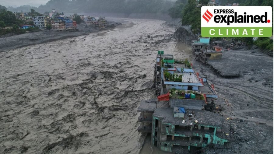
The devastating floods in Nepal have raised fresh questions about how well the Himalayas are prepared for rapidly evolving and cascading climatic and geological hazards.
What began as a sudden glacial detachment developed into a destructive chain of ice, rock, sediment and water, overwhelming communities and critical infrastructure downstream.
Austin Lord is a Senior Fellow with the Energy, Water and Sustainability Program at Stimson Center, the Washington, DC-based non-profit think tank. Lord is Stimson’s Project Lead for Disaster Risk Reduction in the Himalayan Region. He has been closely examining the region’s evolving hazard landscape, including glacier and risk mapping, remote sensing, early-warning systems and the role of local communities in monitoring high-altitude risks.
Story continues below this ad
In an interview with , Lord discusses the sequence of events, the risk of ‘hazard constellations’, what previous mapping missed, and the lessons the disaster holds for Nepal and the wider Himalayas. Edited excerpts:
What consensus has emerged so far (by August 28) on the trigger and sequence of the Nepal flood event?
The present consensus is that the initial trigger was a glacial detachment that included bedrock on the northern slopes of Langtang Lirung, a 7,000-plus-metre peak in the Langtang range. The exact triggering process is not entirely understood. There are theories about what led to the fracture and detachment, but it is clear that the bedrock also fractured and that there was a clear glacial fracture.
That could be related to climate-related risks or gradual shifts at the site. Preliminary analysis indicates there may have been some minor movement of the glacial mass in the weeks or months before the event, followed by a catastrophic tipping point where it failed suddenly.
Story continues below this ad
Once it failed, it swept down through a gully toward the Lhende River, which reaches the Chinese border. The source area was around 5,200 metres, so the flow descended a couple of thousand metres. It deposited a mixture of ice, rock and sediment, creating a temporary natural dam that blocked the river. We don’t really know how long the river was blocked.
There is still debate about how much water came from the glacier itself, from the melting of entrained ice, and from water that accumulated behind the landslide dam. The event was a mixed flow rather than a clear water flow.
There were three major contributors to the water — ice initially entrained in the glacier that became water, the pond created behind the landslide dam, and water already present downstream. Within minutes, the dam failed and sent a major pulse of water downstream.
The mass pushed the water in front of it like a snowplow, creating a flood-surge front. The event reached the China border in roughly nine minutes. Footage from the border facility shows a massive dark wave containing not just water but a large volume of material.
Story continues below this ad
The border facility was at a confluence with another tributary, the Gyirong River. The flow then continued downstream. Within seconds of hitting the Chinese facility, it was already moving back into Nepal. There was therefore no realistic opportunity for people at the facility to warn communities downstream; many of those who could have generated an alert were themselves swept away.
The flow then destroyed dams and hydropower projects downstream, recruited additional sediment, and swept through villages along the river corridor.
The event continued into Nuwakot district and affected larger market towns in the floodplain. These affected areas are well beyond the 100-year or 500-year floodplain. This was a thousand-year-plus flood event, with significant impacts extending more than 100 kilometres downstream. The flood pulse also registered at the India-Nepal border.
This is an unprecedented event in Nepal’s recent history and the most destructive and deadliest flow event of its kind. In the geological history of the Himalayas, other events have occurred, but from a human-impact perspective this is shocking.
Story continues below this ad
The larger issue is the increasing frequency and intensity of cascading hazard chains. We have seen this in Chamoli, Sikkim, with the South Lhonak GLOF, and in Nepal with the Melamchi disaster. Climate risks are interacting with and amplifying other disaster risks. These events are becoming more frequent and more intense.
Was the failed glacier previously identified as a vulnerable site through glacier mapping or risk assessments?
Several places around Nepal have been identified as high-risk areas for glacial detachment and surges. This place was not one of them.
There are glaciers immediately on the other side of Langtang Lirung that are high-priority research sites. The Langtang and Yala glaciers have been extensively studied, including through long-term work by the World Glacier Monitoring Service. There is a lot of science, monitoring and attention in the Langtang Valley.
But this particular location had no red flags. Even now, we are examining whether changes could have been detected in the days leading up to the event, but that would still require knowing where to look.
Story continues below this ad
Monitoring every glacier and every mountainside that could collapse is like looking for needles in haystacks. You need some signal to separate from the noise. That is why remote sensing and satellite-based analysis are important, but different satellite tools answer different questions, and you have to know where to look. One thing I want to put on the record is that, to know where to look, it’s important to engage local communities. Of over a dozen extreme events in the Himalayas over 10 years, almost all came from unknown places, except one, the South Lhonak (Sikkim) glacial lake outburst, which was a known risk.
We are beginning to identify patterns, but there is no training dataset from the Alps or Norway that can simply be transferred to the Himalayas. The Himalayas has their own context and significant data scarcity and data sparsity.
Tell us about Stimson Center’s work with the Nepal government on early warning systems.
The work is still largely in the system-design and beta-testing stage. It began with an assessment of the 2021 Melamchi disaster, asking what parts of a cascading hazard could actually be detected, what tools would be required and what lead time could be provided.
Story continues below this ad
Our work focuses on multi-hazard risk assessment, mapping, horizon scanning and identifying hotspots for prioritisation. We have mapped different hazards in several watersheds, including glacial lakes and active landslides, and created a national inventory of past landslide dams that blocked rivers. I’m comfortable admitting we did not catch this, because no one caught this. There are a variety of reasons why this wasn’t a place that popped up on people’s radar.
We have also modelled landslide-dam outburst floods on the Lhende River and scenarios involving glacial-lake bursts followed by landslides and a second wave of outburst flooding. But we did not have this specific chain of events in our models.
We are a technical partner, not an implementing agency. The Government of Nepal, in collaboration with NGOs and others, has developed early warning systems for floods and some landslides; some of these are successful. Early warning for glacial lakes is also being developed.
Another promising complementary system is environmental seismology. You probably saw that at the beginning of this event, it was thought to have been earthquake-triggered, but it was actually the other way around — the signal was created by the flow itself.
Story continues below this ad
Seismic sensors can detect changes in flows and potentially generate alerts. During the Chamoli disaster, India’s existing seismic network picked up the signal from the event even though nobody saw it coming. With a system designed to interpret those signals and triangulate their origin, it could potentially have generated an early warning.
This would not replace river gauges, weather stations or other systems. It would be a complementary and redundant layer. Nepal should invest in it, although it will not solve everything.
What is the broader lesson for India, Nepal and the Himalayas, particularly when known high-risk sites are not always the ones that trigger disasters?
The kind of mapping exercise undertaken by India’s Home Ministry and space agencies (to monitor glacial lakes and hazards) is an absolute necessity. It provides a baseline. Nepal does not have the same level of resources, and although some mapping has been done, it is not as comprehensive.
Once you have those maps, you can begin hazard zoning and modelling. But the key is monitoring.
Story continues below this ad
Remote sensing and satellite imagery are one part of the triangle. The second is fixed station networks — hydromet and seismic stations. The third is localised monitoring.
You need to engage local governments, disaster managers and Community Disaster Management Committees. They can collect local data, report landslides and monitor impacts after storms.
You also need people who are immersed in these environments. Yak herders and fishermen can notice changes in rivers, glaciers and glacial lakes. Yak herders have been the first to report growing glacial lakes during several events. Oral histories with elders can reveal smaller avalanches, glacial-lake floods and other events that science has not recorded, helping identify potential hotspots.
The critical point is two-way communication. If governments and scientists do not build serious two-way lines of communication with local communities, they will not receive information from the ground. We can be excited about AI-enhanced monitoring systems and satellites, but we also have to invest in these local networks. When you combine the station network, remote sensing and localised monitoring, you have a better chance of detecting changes and distinguishing the signal from the noise that tells you where to look.
Nepal floods: The Himalaya are not a blank canvas for grand infrastructure
By Sohail Khan · 31 Aug
Fox-faced and fruit-loving: What makes this Indian bat so unique
By Sohail Khan · 31 Aug
‘A lot is unsaid’: Neha Dhupia on gestures that define her marriage with Angad Bedi
By Sohail Khan · 31 Aug
Leave a Reply