Assam floods aren’t just about the Brahmaputra. Broken landscapes are causing devastation
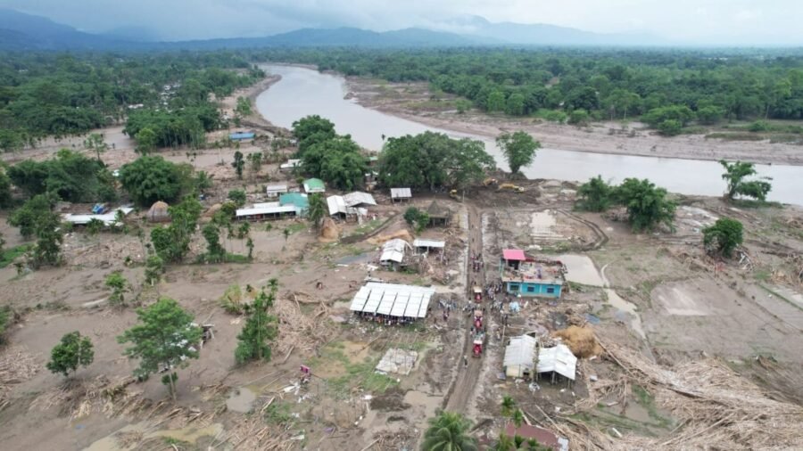
In the third week of July, several south-bank rivers of Upper Assam rose with terrifying speed, unleashing torrents that swallowed paddy fields and grazing lands and swept through villages and towns. Several districts, once strangers to such catastrophic floods, suddenly found themselves engulfed in a disaster beyond imagination. Thousands of hectares of crops vanished under floodwaters, livestock were lost, and vital infrastructure — embankments, roads, bridges, schools, and homes — lay in ruins. These numbers barely hint at the true scale of devastation in regions whose hard-won prosperity was built over generations.
This catastrophe is remarkable not just for its sheer scale, but for the unique pattern it has carved across the land. To dismiss it as just another unlucky monsoon year is to miss the deeper story: Assam’s growing vulnerability to floods is rooted in a long history of shrinking safety margins in a landscape that, for centuries, enjoyed a stability now lost. Upper Assam felt the brunt of the disaster even before the Brahmaputra swelled to its highest. News spread quickly: Relentless July rains pounded the Naga Hills and Arunachal Pradesh, soaking the slopes and unleashing sudden torrents into the southern tributaries. Many pointed to the region’s land use — stone and boulder extraction from riverbeds and hillsides, a common sight in both highlands and lowlands — as a culprit that hastened the rainfall’s journey, turning it swiftly into catastrophic floods downstream.
Advertisement
To correctly understand Assam and its natural rhythms, one must look beyond its borders and into the vast environmental complexity that surrounds it. Cushioned between the Eastern Himalaya to the north, the Patkai and Barail ranges to the east, and the Bay of Bengal to the south, Assam is shaped by multi-layered environmental forces that have worked together for millennia. Of these, the southwest monsoon weaves together highlands, floodplains, billions of tonnes of sediments, and the ever-shifting channels of hundreds of rivers, creating a living, interdependent system. Each year, the monsoon decides whether Assam will bask in gentle rains or battle devastating floods. The July 2026 flood brought this reality into sharp focus: rainfall far beyond Assam’s borders unleashed waters that surged across its land. To see Assam in isolation is to miss the deeper origins of its most dramatic events.
The highlands of Nagaland and eastern Arunachal Pradesh, which feed the rivers of the south bank of Upper Assam, have undergone dramatic land-use transformations in recent decades, echoing changes across the Himalayan and Patkai landscapes. Driven by growing populations, cultivation cycles have become shorter and more intense. Where once a colonial system of extraction dominated, today small-scale coal mining, woven into the fabric of local economies, thrives through complex networks of speculators. Such pressure on uplands, along with relentless logging and expanding infrastructure, erodes the land’s ability to absorb rainfall. In other words, in a landscape stripped of forests, reshaped catchments, and squeezed floodplains, the land’s ability to soak up rain has withered. These shifts ripple across the hill states of Northeast India and the wider Himalayan arc. The mounting pressure on Assam’s upper catchments is a symptom of a broader regional surge in resource extraction outpacing the reach of institutions.
The south-bank districts of Upper Assam, at the heart of the recent flood, were once among the Brahmaputra Valley’s most resilient regions. Thick forests, scattered settlements, and a safe distance from the Brahmaputra’s main channel defined these lands. But in the mid-19th century, this calm began to unravel as these areas drew the attention of colonial tea planters. The forests fell to make way for tea gardens, soon followed by coal and petroleum extraction, which brought railways and stripped away even more trees. Where rain once vanished quietly into the forest floor, the land was transformed into sites of plantations, mineral extraction, and farms that could no longer hold back the water — a change that left these districts most exposed.
Advertisement
The loss of forest deepened when, in the mid-20th century, a techno-bureaucratic campaign to build embankments set out to shield settled floodplains from floods once seen as both predictable and nourishing for agriculture. These barriers interrupted the natural flow of sediment, and the illusion of safety they created drew more people to settle in the very lowlands most at risk. By 1988, even after thousands of kilometres of embankments had been built, two-thirds of the valley still lay open to flooding. The July floods echoed this history. Embankments along the southern tributaries gave way before the main river even crested, unleashing sudden breaches instead of the slow, familiar rise and fall of water on an unembanked plain.
This inherited vulnerability has now deepened, as shown by new evidence that the monsoon is fast transforming. Meteorologists report that India’s rainy season has become more unpredictable, marked by sudden downpours separated by long, dry spells rather than simply more rain overall. They point to the warmer air’s greater thirst for moisture, which fuels fiercer storms when the skies finally open. Studies focusing on Northeast India echo these findings. This growing gap between wild rainfall and a weakened landscape paints a fuller picture of these flash floods than simply focusing on rainfall intensity ever could.
The catastrophic flooding in Upper Assam is not just a seasonal misfortune but the outcome of vulnerabilities that have quietly built up over nearly two centuries in a monsoon landscape. Changed highland catchments, embanked and settled floodplains, and a climate that grows more unpredictable each year have all chipped away at the region’s historical resilience. Unfortunately, Assam’s wilderness has often been treated as a puzzle for engineers to solve, with each crisis tackled in isolation, rarely considering the deeper ecological story that binds the landscapes together. Assam’s environment is inching closer to its tipping point, but it is not yet beyond repair. We need to understand and retain the intricate connections between highland and lowland, water and land, forests and floodplains, and accept that the resilience lost over generations cannot be rebuilt by technology alone.
The writer is a Guwahati-based environmental historian

Between Trump’s US and Xi’s China, the trap India must avoid
By Sohail Khan · 28 Sep
Farmers need a share of the solar boom
By Sohail Khan · 28 Sep
Fraying exchange of ideas, and a world torn by conflict
By Sohail Khan · 28 Sep