52 km, 5,630 metres, half the oxygen: Why the Kailash yatra is an ordeal
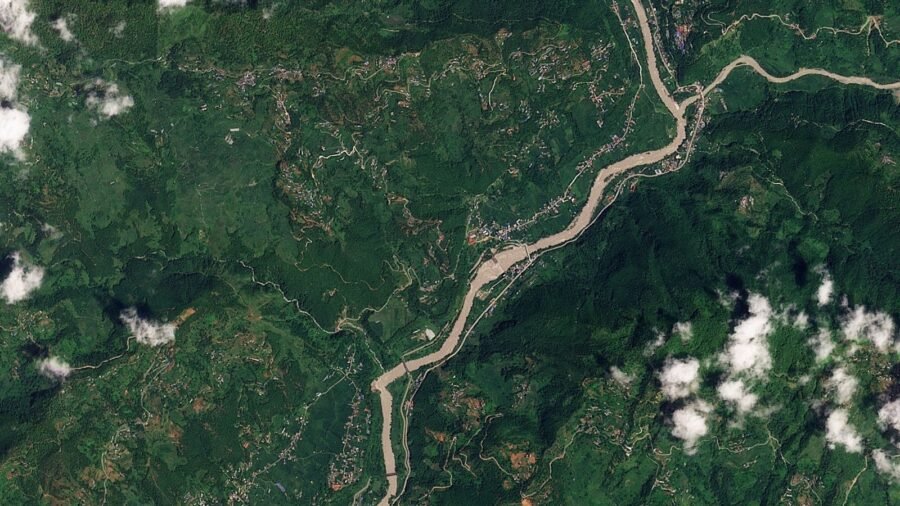
They have faith. Faith in God.
For millions of Hindus, Buddhists, and Jains, and practitioners of Bon – Tibet’s indigenous religious tradition – there are few pilgrimages more sacred than the roughly 52 km parikrama, or trek, around Mount Kailash. One circuit, it is said, is worth 12 years of penance.
And so, every year, tens of thousands of pilgrims set out for Mt Kailash and the walk around its base, trudging across some of the most rugged and inhospitable terrain in the world.
Story continues below this ad
Many, having reached Kailash, turn back midway, defeated by the Dolma La pass – at 5,630 m above sea level the highest point on the parikrama – or are starved of oxygen. Some are turned back by a different sort of avalanche – a rush of paperwork for any one of a handful of permits demanded by the Chinese.
But in August 2026, some were turned back even before they could embark on the parikrama.
They were turned back by a wall of ice and rock that fell into the Bhotekoshi River in northern Nepal, and the torrent of muddy water it unleashed. It tore through brick-and-mortar buildings like they were made of cardboard and swept away villages in seconds, and, with them, any illusion that faith alone is enough.
The Kailash Manasarovar yatra may be the only pilgrimage in the world where geography, politics, and physiology all have a say on whether you finish. And then God decides.
Story continues below this ad
What happened on August 26
The clock struck 8.37 am. Or it might have been 8.38. Somewhere up in the mountains on the Nepal-Tibet border there was a glacial collapse. It felt like an earthquake but it wasn’t.
Within minutes, possibly seconds, possibly with the echoes of the ice and rock still falling into the Bhotekoshi, and a surge of water poured downstream, causing the river to swell and the valley to flood.
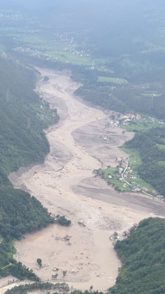 Aftermath of flash floods in Nepal’s Rasuwa district on August 26, 2026. Pradip Pandit/Alpine Kailash Trek Pvt Ltd / via REUTERS
Minutes and hours later Nature’s fury had destroyed roads and bridges, crushed houses and power plants, and carried away hundreds of people in its wake. Alarm bells rang downstream but it was too late; soon photos and videos emerged online, a digital catalogue of a physical disaster.
The death toll began climbing and hasn’t stopped. By the time this was written it stood at over 270 with at least 1,300 missing, including roughly 300 Indians, of whom around 100 may have been on the yatra.
Story continues below this ad
A route built to fail
This wasn’t bad luck. It was geography.
The Bhotekoshi flash flood ran through a corridor that is critical to the Kailash Manasarovar yatra, a route to which there are few real alternatives. In fact, there is no direct route to Kailash at all.
The commonest starting point is Darchen.
But to reach Darchen you have to get into Tibet. And that means convincing the Chinese authorities to give you permission.
And of the hundreds of thousands who apply every year – including Indians – only a handful are allowed through. For Indians arriving via Nepal – which is the more travelled option – Beijing capped the 2026 quota at 24,000. Tens of thousands applied.
Story continues below this ad
For those lucky thousands it also means crossing a handful of routes carved through some of the most unstable terrain in the world.
The Bhotekoshi corridor was one of those; reports say an immigration facility operated by the Chinese on the Tibet-Nepal border was washed away in seconds in one shocking video.
There is no detour really, no shortcut. Unless you’re a mountain goat. For the pilgrims who were crossing, or were waiting to cross when the torrent hit, it was the only way in… and it has failed before.
In July 2025 – 14 months earlier – a smaller flood washed away a bridge and killed nine people.
Story continues below this ad
In hindsight, that may have been a warning. Only, no one listened.
This funneling of large numbers of people through high-risk corridors is what, many would argue, makes disasters like this possible. And, for the pilgrim, arriving is only half the ordeal.
The three-day circuit
Now, the parikrama itself doesn’t begin at the mountain. It begins at Darchen, a small town 4,560 meters above sea level that is widely used as a base camp. The gateway is Yamadwar, a short drive away.
And that’s where it all starts. Pilgrims pray here before starting the walk. It takes three days and each asks more of you than the last, especially when you get to Dolma La.
Story continues below this ad
First up is a gradual climb – roughly 650 metres – to Dirapuk monastery. It sounds simple but it is enough to leave most pilgrims lightheaded. And then comes the climb that breaks some people – Dolma La.
MAP: Kailash Yatra Route & Bhotekoshi Disaster Zone
🚨 Flood Point: Tatopani / Zhangmu
🏔️ Base Camp: Darchen (4,560 m)
⚠️ High Pass: Dolma La (5,630 m)
First up is a gradual climb – roughly 650 metres – to Dirapuk monastery. It sounds simple but it is enough to leave most pilgrims lightheaded. And then comes the climb that breaks some people – Dolma La.
Here the air holds roughly half the amount of oxygen the body is used to. And it panics. It starts making adjustments, trade-offs… your heart-rate spikes and the lungs work overtime. To provide that boost the body shuts down or slows elsewhere… slower reflexes, brain fog, poor judgment.
Story continues below this ad
The kind of confusion that could lead you to make a fatal step on a narrow mountain pass.
And then you cross Dolma La. But the battle isn’t over.
The climb down is a challenge too. You drop nearly 500 metres to Zutulpuk and by now your knees are being punished. But you can’t stop. Not here. The third day dawns and now it finally starts to get easier. The gentler descent back down to Darchen. The circle is almost done.
This is what Mt Kailash asks of a pilgrim.

Prime Minister Modi to begin 4-day visit to Uzbekistan, Kyrgyzstan on Aug 29
By Sohail Khan · 27 Aug
A special session plan for delimitation Bills? Congress chief’s letter to PM
By Sohail Khan · 27 Aug
A decades-old friendship, two tea families and the making of India’s first commercial matcha
By Sohail Khan · 27 Aug
Leave a Reply