Nepal floods: The red flags in dam-building in the Himalayas
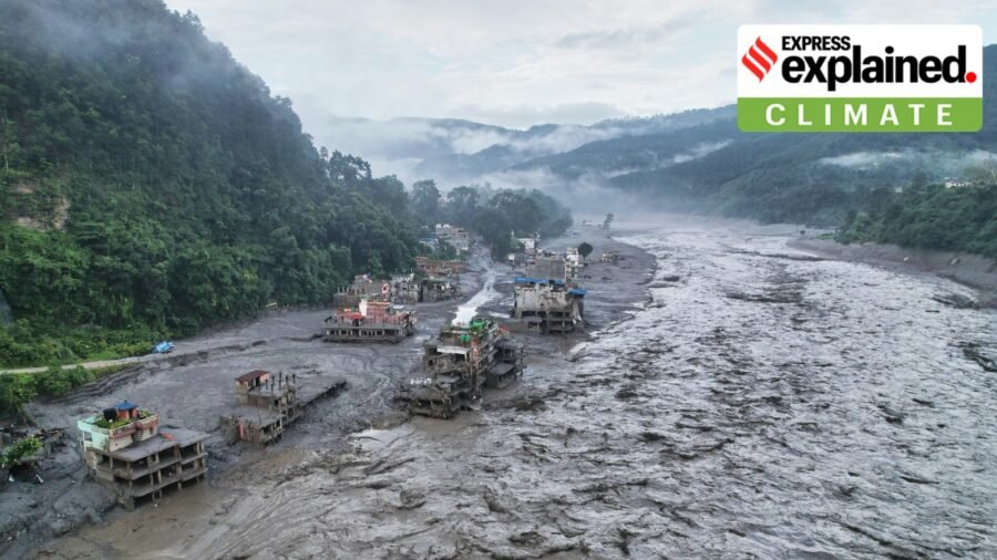
Five days after a glacier collapse near the China-Tibet border triggered floods, over 734 people have died, and over 3,000 others remain missing, including nearly 320 Indians.
The large-scale fallout, however, does not mean that the event was a rare occurrence. The Himalayan region is all too familiar with other similarly destructive phenomena. The event has also led experts to reiterate concerns about recent man-made changes, ranging from infrastructure buildup to high tourist volumes, all occurring amid quickly changing climatic conditions.
Y Nithiyanandam, a professor and the head of the Geospatial Programme at The Takshashila Institution, Bengaluru, told , “The Himalayas are a naturally fragile mountain system, already prone to earthquakes, landslides, avalanches and flash floods. What climate change may be doing is increasing the underlying vulnerability.”
The geology
Story continues below this ad
The Himalayan topography includes lakes formed by melting glaciers, fast-flowing rivers and steep slopes. They dot a region highly vulnerable to strong earthquakes and disproportionately affected by climate change.
In a 2022 article for Nature, researchers highlighted that “High Mountain Asia (HMA), the Earth’s most important and vulnerable water tower, is warming at a rate that is double the global average (0.32°C per decade compared with the global average of 0.16°C per decade).” The HMA includes the Tibetan Plateau and surrounding ranges, like the Himalayas.
Temperature changes affect the pace and frequency of natural processes, including the melting and thawing of snow and glacial lake outburst floods (GLOFs) or when water collected from melting glaciers overflows.
Nithiyanandam said that a warming planet means less snow cover in some areas. “The relatively darker glacier ice gets exposed, absorbs more heat and can melt faster, weakening glacier fronts. In such conditions, an earthquake, heavy rainfall or sudden ice movement can become the immediate trigger,” he said. While linking any one disaster directly to climate change still needs more scientific assessment, the overall risk appears to be increasing, he added.
Story continues below this ad
Mirza Zulfiqur Rahman, a researcher on the Brahmaputra river basin, told that in this particular flood, aspects including infrastructure build-up and high tourist footfall have compounded the disaster’s toll.
The build-up
Dams and reservoirs can regulate the flow of water and provide wider access to services for people living in remote regions.
But they also increase vulnerability. In the recent floods, 13 hydropower plants, including several under-construction projects, were affected, denting power generation capacity and access. In turn, Rahman said, “Building a dam also shakes up the geology of the area and makes it much more prone to earthquakes. A lot of drilling and a lot of tunnelling is happening in order to build more… ultimately, the Himalayas are going to be its biggest casualty.”
Story continues below this ad
Nithiyanandam agreed that hydropower development across the Himalayas is now extensive, with hundreds of projects in various stages of completion. “One recent study identified at least 193 dams built or planned across the wider Tibetan region since 2000, while a Nepal hydropower database lists more than 570 projects at different stages,” he said.
China is often seen as a leader in installing infrastructure projects, including the massive under-construction dam on the Yarlung Tsangpo river (the upper course of the Brahmaputra) near Arunachal Pradesh, but others are amping up construction as well.
“Chinese infrastructure building in Tibet is of concern. Obviously, China also looks at its infrastructure building in Tibet in a very different manner, as sovereignty markers over Tibet. India, Nepal, and Bhutan have also responded to it in a similar manner and come up with their own set of dams. India is also helping Bhutan build a series of hydropower dams, making this part of a larger geopolitical game, signalling and counter-signalling,” Rahman said.
In July, Chinese researchers flagged an active fault line (a fracture between two blocks of rock) directly beneath the Yarlung Tsangpo mega-dam. According to a report in the South China Morning Post, they said the terrain around the project has a “loose structure and weak cohesion”. Even without any one country acting in bad faith, the risks of large projects in the Himalayas are naturally significant.
The gap
Story continues below this ad
As disaster risk rises, so could the scale of devastation, but experts flag continued lack of adequate communication among Himalayan nations, which could help mitigation and planning. Rahman said, “There has not been substantial cooperation between China and Nepal or China and India in terms of how we really manage the ecosystem.”
Some disasters in the 2000s prompted a Memorandum of Understanding between India and China in 2002, with an expert-level mechanism on transboundary rivers created in 2005. “Such mechanisms also have to be expanded to include other aspects such as GLOFs,” Rahman added.
Nithiyanandam said the key difference was transparency: “Nepal officially publishes fairly detailed project and licensing information, whereas in China project-level information is available but remains scattered across different official documents and announcements rather than through a comparable consolidated public database.”
Gaps in information and data-sharing between countries can complicate early warning for hazards originating across the border. “There is no clearly established public system between China and Nepal for continuous, real-time sharing of upstream river flow, reservoir operations or glacial-lake conditions from Tibet,” he added.
Story continues below this ad
Stronger transboundary cooperation would necessarily include continuous sharing of hydrological, weather and climate data. “Where sustained monitoring has a cost, downstream countries could also co-invest in upstream observation systems or pay for specialised datasets, creating a model that benefits both sides. Automated public warning systems, joint scientific studies and regular emergency exercises should complement this,” Nithiyanandam said.
Rahman pointed out that downstream countries also lack consensus to build alliances that can deal better with China. “In that sense, there is no scope for international arbitration. But even if they had signed agreements to that effect, China does not really follow those kinds of international norms, as we can see in the South China Sea dispute as well,” he said.
That possibility, however, does not take away from the necessity of such processes. “A nation-state-centric, container approach in the Himalayas does not make sense because all of these disasters really do not limit themselves strictly within national boundaries. It has ramifications all across the landscape, and hence the solutions also need to be applied to that end. Scientific research also has to be done from a landscape perspective to actually create any sustainable form of infrastructure development in the Himalayas,” Rahman said.

Heart attacks in fit women in their 30s and 40s: The hidden risk doctors want you to know
By Sohail Khan · 29 Sep
40 years ago September 29, 1986: Violence and arrests in Punjab
By Sohail Khan · 29 Sep